Geo-Characterisation of Highway Construction Cost Drivers in the Niger Delta Region of Nigeria- Juniper Publishers
Civil Engineering Research Journal- Juniper Publishers
Introduction
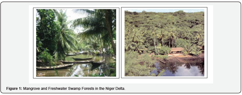
The Niger Delta is the 9th largest Delta in the world with an area of 19,135 square kilometres. It is one of the largest wetlands in Africa. The whole basin is dissected by numerous creeks, streams, marshes, and lagoons [1]. The terrain of most parts of the Niger Delta is characteristically poorly drained, from the inundation of the adjoining lowlands forming swamps and coastal islands. However, the upper northern limit of the Niger Delta, is characterized by tropical rainforest woodland (Figure 1). This is the zone with the most extensive dry land, and the population distribution is denser, with far larger settlements than other wetland zones. This heterogeneous configuration of the terrain thus has correspondingly varying geotechnical implications for highway development.
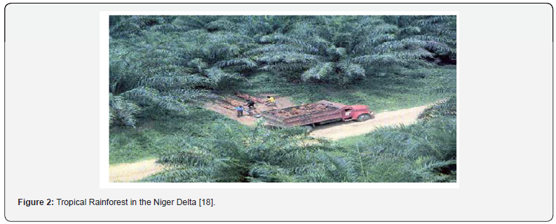
The environmental condition of most parts of the Niger Delta makes the use of conventional pavement designs, materials and construction methods particularly in the swampy and coastal zones, inappropriate (Figure 2). The silted and marshy grounds of the swamps are representative of the difficulties of undertaking any major construction in the area. Most of the soils encountered are soft and present sub-grade problems and have high water tables [2]. Several scholars in the literature: [1-4] have consequently underscored the technical and financial undertones. This implies that pavement construction in these zones would ideally require expensive specification for works, ultimately increasing the cost of construction projects so many folds, compared to the uplands. The logical cost implications of the heterogeneous geologic setting of the Niger Delta soils for road construction can thus be viewed from the point of:
a. relatively higher design and specification requirements necessary to adapt the subsoil conditions in the swampy and coastal zones.
b. additional cost/expenditure that may likely be incurred during construction of projects situated in the swampy and coastal belts.
The subsequent subsections analyse the geo-variability of the terrain, and the financial issues that arise due to the practicalities of carrying out road construction in the Niger Delta occasioned by adverse ground conditions. This is with a view to highlight the impact of the geomorphology of the region on highway construction costs.
Geo-morphology of the Niger Delta- Implications for Highway Construction
The general geology of the Niger Delta consists of various types of geologic deposits. Short & Stauble [5] identified three main subsurface litho-stratigraphic units in the Niger Delta in order their age: the Benin formations (water bearing zone); the Agbada formations (middle); and the Akata formations (base). In addition, these are overlain by the quaternary deposits, representing the top 40-150m of the land surface [3] corresponding the quaternary period, which is the youngest period of the geological time scale. The rocks and sediments of the quaternary period are of widespread occurrence on the land surface. They tend to blanket all older deposits, except for a few exposures. As a result, quaternary deposits lie directly within the influence of construction works in the region and has being given considerable scrutiny from scholars in the various interrelated construction disciplines. For highway construction, it is the topmost layer of the quaternary deposits, which represents the subgrade soils, that is of significance and thus discussions on their suitability for construction purposes are limited to this layer. Oguara [2], analysed the properties of quaternary soils for road construction with regard to their engineering application, stating that: “Most of the soils encountered are soft and present subgrade problems. The depth of ground water table also exists within the reach of conventional foundation types”. Quaternary deposits in the Niger Delta however show a wide spatial variability with frequent irregular dispersion of sand and silt/clay intercalations with the clay ratio increasing seawards. Its thickness is very variable and goes up to 500m in certain places consisting of silts, clay, fine and silty clays, sands and shale. This combines with the alternating predominantly sands and clay profile of the Benin formation, and the high quantity of rainfall in the area to determine the distribution and depths of groundwater in the area. Sub-soils in the riverine areas of the Niger Delta, predominantly consists of extremely soft deltaic marine clay locally referred to as ‘Chikoko’, which often have CBR values less than 2, with a dark grey, dark brown to black coloration [6]. Fatokun and Bolarinwa [7]in identifying the major problem soils of Nigeria described those existing in the sub-soils of the Niger Delta as: “Composed of ‘Peat, Organic silts and Clays characterized by dark colours and strong odour which are highly compressible with low strength” (pp 3). In the Niger Delta region, these soil types occur as clayey peat over the mud plains and have been shown to be highly undesirable in their natural forms for road construction. This is due to their characteristic swelling and shrinkage potential with corresponding changes in water content as seasons change from rainy to dry. Thus, any structure including road pavement constructed with or placed on such soils exist to grapple with such typical geotechnical problems, in the absence of adequate ground engineering.
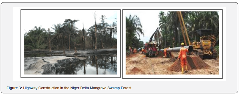
Youdeowei and Nwankwala [8] recommended the excavation of these soft expansive soils and replacement with suitable locally available fill material such as sharp sand. Zumraw [9] opined that this is an economical option to reduce the thickness of pavement required in expansive soils (Figure 3). However problematic swelling chikoko soils existing to irreplaceable extents both laterally and vertically, within the freshwater zone of the Niger Delta is also an established fact [7 & 10]. The views Abam et al. [11] which echo those of Chukweze as well as several other earlier scholars in the literature. Akpokodje [3 & 4]; Oguara [2] and Teme [1], have consequently underscored that the terrain of the Niger delta apparently has cost inducing potentials, which runs negative to the ideal for construction works. Subsequent to these earlier studies, several more recent works have being carried out, by mapping out and studying specific areas in the region. Notable works that have being published include: Omotosho & Ogboin [10]; Youdeowei & Nwankwala [8]; Otoko, [12]; Youdeowei [13] and Ngerebara et al [14]. Other related studies on the suitability of sub-soils for road infrastructure development include Technical Reports by George and Atuboyedia [15], Fatokun & Bolarinwa [7] and the Nigerian Building and Road Research Institute (NBRRI). These field work based studies have collectively stressed that the geotechnical difficulties inherent in the Niger Delta call for measures in designs and during construction to ensure an adequate margin against the behaviour of these naturally weak soils. The effort and methods requisite to improve the geotechnical properties of soils, and to attain the standard minimum engineering requirements, has direct and indirect costs which correlates with the poorness of of the subsoils prevalent at the locality.
Subgrade Characterisation of the Niger Delta
Various engineering parameters have been used to assess the suitability of sub soils as bearing media for the construction works. For road construction, the engineering properties of the superficial sub-grade soils influence the designs and costs of construction. The geotechnical parameters show the capacity of the soils by providing descriptive and quantitative representation of sub-soil strengths and constraints. Descriptive parameters include grain size distribution used in soil classification. Grain size analysis is used to identify the sizes of particles which make up a soil sample to produce a grain size distribution of soil particles [16]. Uniform graded soils are referred to as poorly graded or gap-graded on the basis that the ideal mix of the various size range of particles is skewed and as such predominantly contain one particle size all (small or all large). Soils consisting mostly of gravel (>2 mm) and sand (0.1 –2 mm) are referred to as coarse grained while silt (0.01 –0.1 mm), and clay (< 0.01 mm) which are the typical grain size of Niger Delta soils, are fined grained soils. Youdeowei [17] explained that poorly graded soils will have relatively low densities and low strength, since the number of particles per unit area and interlocking frictional forces is small, which reduces their structural stability for road construction. In such soils, it was thus stated that modifications of the natural properties of the sub-grade soils may be required.
To identify such soils in engineering application, two common classification systems, the AASHTO and the Unified Soil Classification System (USCS), are used for this purpose of classifying soils based on grain size, with standard designations for different soil particle size mixes. The ASSHTO classification system has 8 major groups: A1~ A7 (with several subgroups) and organic soils A8–. with a corresponding progressive decrease in the suitability of the sub-grade soils from A1 to A8. Based on available field data for 61 spatially distributed coordinates, the approximate descriptive geotechnical properties of subgrade soils are presented in Table 1, using the AASHTO system.
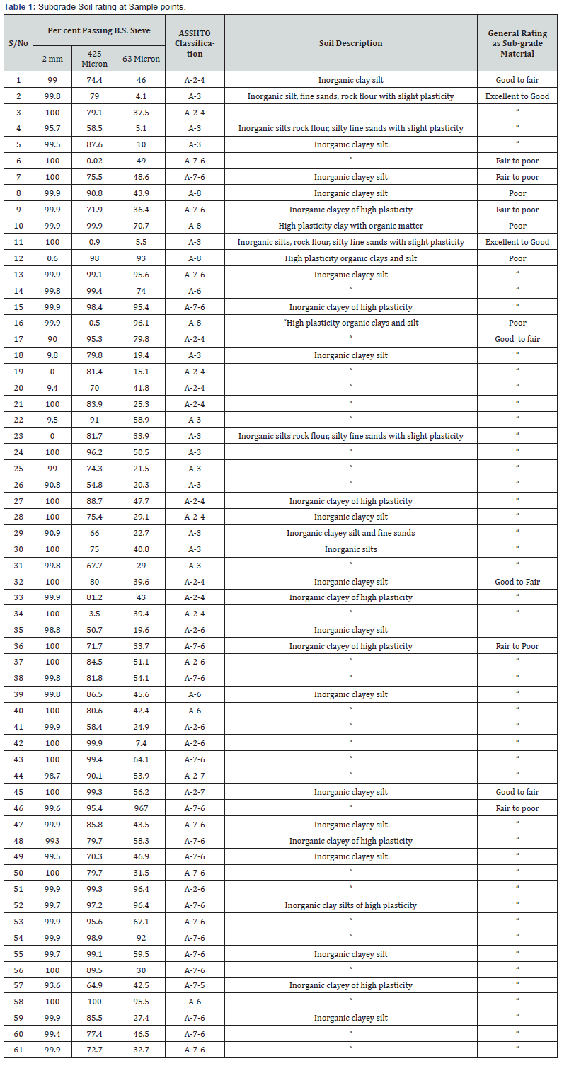
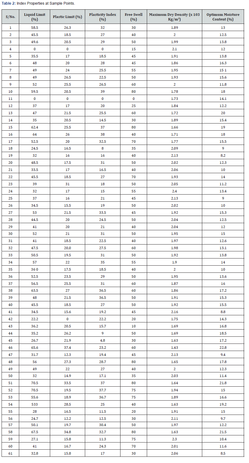
It can thus be discerned that about two thirds of the soil types in the Niger Delta fall within the lowest range of soils (A- 6, A-7-6 and A-8) classified as fair to poor sub-grade soils in engineering application, due to the high percentage of very fine grained soil particles (Less than 2mm). The prevalence of finegrained particles in the Niger delta soils, limits the applicability of the soils as bearing media for highway pavement construction. Although the particle size distribution and classification are useful in providing a broader picture of the engineering applicability of the soil types in the region, they are more descriptive. Other more quantitative geotechnical parameters such as plasticity, free swell and maximum dry density correlate to give more specific geotechnical attributes of sub-soils. The index properties of the Niger Delta soils at spatially dispersed locations are presented in Table 2.
As the data shows, finer grained soils are predominant in the Niger Delta region, particularly in the swamps and coastal areas. The Atterberg limits (Plastic Limit and Liquid limit) as well as the Plasticity index show that the subgrade soils in the region are highly plastic. Highly plastic soils display high volume changes with the introduction of moisture. The occurrence of such soils has been noted to be problem soils in the region, as they are associated with significant volume changes with progression from dry season to wet [6 & 8]. The liquid limits of sub-grade soils in the Niger Delta have a range of 70.5% varying between 0 and 71%, with a mean value of 40, with plasticity index ranging from 0-39%.
The free swell of soils in the region have values ranging from 0 to as high as 80%. The average free swell (50) depicts a high swelling and compressibility potential of soils in the region Table 3. The range of values of maximum dry densities at optimum moisture contents of between 8.2% and 22.8% respectively fall between 1430 kg/m3 and 2400 kg/m3with a mean of 1430 kg/m3. The plasticity index and swelling potential of the Niger Delta soils can thus be inferred as an indication of the how much financial constraint is posed by ground conditions to highway construction. Higher design requirements in pavement and drainage designs as well as adequate re-engineering of the soils is thus a pre-requisite for highway projects, implying:
a. Requisite changes in the level of excavation or fill, subsoil drainage,
b. More compaction requiring the use of more powerful plants,
c. Stabilisation of subsoils
d. other site-related practicalities required in managing such soils during construction.

Typically, Otoko and Pedro [6], Otoko and Precious (2014) as well as Otoko [12] have investigated various cost effective stabilization alternatives suitable to improve subgrade soils in the Niger Delta. These include cement stabilization of laterite and chikoko soils using waste rubber fibre or with groundnut shell ash.
Pavement Design/Cost Interpretation in the Niger Delta
The predominance of fined grained subgrade soils will logically portend significant construction costs [18]. This is view of the fundamental requisite feature of sub-grade soils for highway construction. The resistance of soils to deformation under imposed vehicular load, underlies the philosophy of pavement design). The California Bearing Ratio (CBR) named after the California Highway Department, is one of the fundamental methods based on evolving experience of sub-grade failure, adjudged to be a reliable composite index of sub-grade strength, whereby soils have to be tested using specified testing procedures under simulated dry and wet conditions [19]. High CBR vales indicate good strength while very low CBR values are typical of highly plastic clays with volume instability. Strength of sub-grade are determined from standard geotechnical testing procedures and are also given in interval ranges of six CBR classes; S1 to S6. The poorest soil class being S1 having a CBR value of 2% with the best soils having values above 30%. The six CBR classes that are provided (S1 to S6) with a minimum value of 2 for soft soils as follows:
a. CBR, 2.0 % (S1) .......... Very soft ground.
b. CBR, 3.0 – 4.0% (S2) .......... Soft ground.
c. CBR, 5.0 - 7.0 % (S3) .......... Medium hard ground.
d. CBR, 8.0 - 14.0% (S4) ............Hard ground.
e. CBR 15- 29% (S5) ............Hard ground.
f. CBR 30 (S6) ............Hard ground.
Using the CBR estimates of the thickness of each pavement layer relative to material strength can be made. According to Ngerebara et al [20], this approach to flexible pavement design in the Niger Delta has gained credibility in highway designs, as other geotechnical properties correlate very well with the CBR. The Nigerian standard of road designs principally adopts this CBR philosophy, from the Transportation and Road Research laboratory (TRRL) Over Seas Road Note 31 [21], which serves as a guide to the Structural Design of Bitumen-Surfaced Roads in Tropical and Sub-Tropical countries [22]. It is the basis for road designs which is used by the Federal Ministry of Works (FMW) without much modification. Based on the CBR philosophy, the thicknesses of the cross sectional elements: surfacing; binder course; base; subbase; and capping, in a series of standard material combination for different traffic and subgrade classes are provided by TRRL Over Seas Road Note 31 [21]. The structural catalogue specifies up to 8 variants of differing materials and standard thicknesses to be deployed based on the relevant combination of CBR and traffic class.
The combined thickness of the pavement structural layers, from sub-grade to surfacing, based on this subsoil designation increases from 200 to 300mm for S6 (Hard ground) soils , up to 650-1000mm for S2 (Soft ground) soils. The implication of the choice of a particular design is the influence it has on the volume and nature of construction materials which are needed. Newcombe and Birgisson [23] analysed the CBR relative to the required thickness implied by structural relevance of the base layer in a typical flexible pavement and the contribution of the granular base to the overall structural capacity. As Newcombe and Birgisson [23] show, high CBR values translates into a reduction in required base layer thickness. Similarly, the United States Department of Transportation [24] analysed the financial sensitivity of designs in response to subgrade CBR properties. The study showed that the CBR of subgrade soils is a good representative indicator of the overall sensitivity of pavement costs to geotechnical properties of subgrade soils Based on the analysis, at a traffic loading of 10 million ESALs and a subgrade CBR of 8, the anticipated cost per 850m2 of surface area of pavement is about $12,800 relative to $15,600 for a poorer quality of sub-grade with a CBR value of 4. This represents an increment of 20% of costs to for the same area of pavement section.
This analogy directly reflects the variable cost of construction considering the predominantly adverse soil profile in heterogeneous terrain of the Niger Delta, which has soil types ranging between extremes. For locations with CBR’s less than 2, which are typical of the expansive clayey peaty soils of the swamps and coastal areas, the TRRL [21] guide outlines the need for special treatment. As such problematic marine clays/peat (Chikoko) soils, rated as very poor, with characteristic shrinkage and swelling potential, abound in the riverine areas, will require remedial re-engineering measures [2,13,25]. Such reengineering will imply additional costs for either:
a. Excavation to remove such poor soils to the extent of prevalence, and replacement with adequate fill materials
b. Compaction and preloading with locally available free draining material
c. Stabilisation in place with chemical additives to achieve the required minimum strength characteristic for the sub-grade.
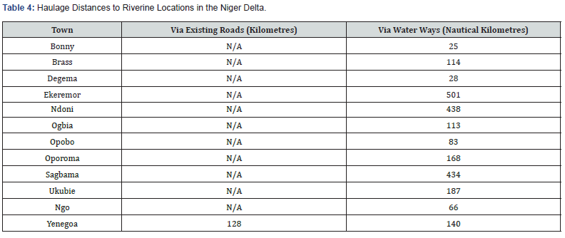
Such measures will entail importing good quality laterites with high CBR from burrow pits, subject to the availability of source sheds and the haulage distance from these source locations, often situated in the coastal plain soils of the Upper Delta, to construction sites in the swamps and along the coast. Table 4 shows the distances of some riverine and upland locations in the Niger Delta from Ahoada, via Port Harcourt, situated in the coastal plain soils of the upland regions, which has estimated lateritic reserves in excess of 15 million tonnes. The swampy and coastal regions which are often cut off by lack of existing roads to transport materials, are suggestive of the prohibitive cost of replacing such poor soils with suitable materials. The additional costs of loading of materials at source, spreading and compacting and backhaul (return of empty vehicle) equally push up the cost of this subgrade improvement technique.
Drainage Design/Cost Interpretation in the Niger Delta
Road surface water drainage is principally required to drain both the carriageway and the surrounding catchment of the drain. 10% of the total cost of road construction, is required for drainage. Drainage construction cost requirement is however location specific and will to a significant extent be a determined by the relief and precipitation parameters and ground water levels at the location.
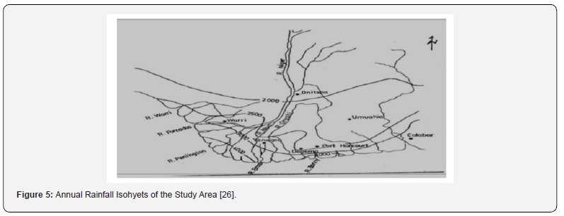
The relief of the Niger Delta region is that of a broadly flat, gently steeping topography, from a height ranging from 40m to 8m above sea level, inland to the coast (Figure 4). Rainfall is typically high in the Niger Delta, with a progressive increase southward towards the coastline, due to regular heavy downpours. Ngah and Youdeowei [26] reveal annual rainfall isohyet values across the Niger Delta which also shows a progressive increase seaward from the inlands (Figure 5). The Nigerian Meteorological services (NIMET) records reveal very high levels of annual average rainfall (5000 mm), with a reduction towards the middle Delta, while the upper Delta experiences the lowest values ranging between 3000 mm to 2000 mm. Table 5 shows the average rainfall amount for some locations in the Niger Delta.

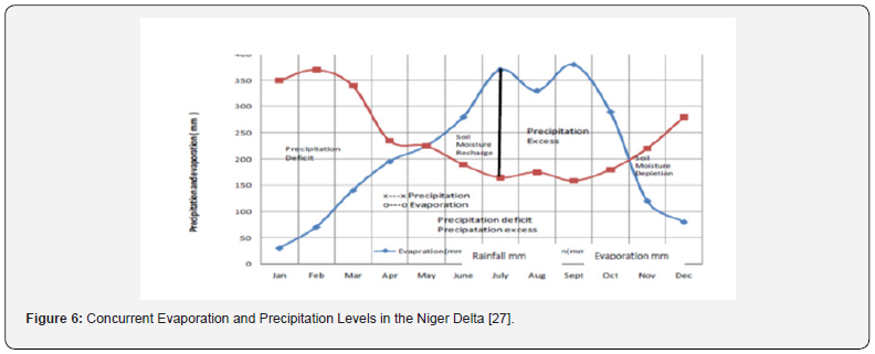
Weather pattern coupled with relief determine the quantity of overland flow over the Niger Delta region, which evacuate via a reticulate network of meandering system: creeks, streams and rivers, 18 of which discharge directly into the Atlantic Ocean. Due to the high volume of rainfall, low evaporation and the predominantly poorly draining fine grained soils, flooding is a major issue in the region with about 50% of the landscape regularly inundated by floods during the rainy season. Abam [27] analysis of rainfall and concurrent evaporation indicate that the amount of precipitation excess is comparatively large during the rainy season months (Figure 6). Almost every part of the Niger Delta is thus under water at one time of the year or another. The northern part, which is the habitable part, remains dry after the rains and floods except for the large swamps referred to above. This is because since the sandy riverbed soils are porous and very pervious, there is a rapid rise in the ground-water level, a process which subsequently floods the lowlands.

The depth of ground water table in the Niger delta also exhibits seasonal variability, in response to rainfall distribution: 7-10m in the uplands and 0-5m along coastal zones. Abam [27] however, asserted that in the swamp zones with minimal ground water depths (0-0.5m), this variability is more closely linked to the topography. Groundwater recharge in the Niger Delta is primarily by precipitation. (Figure 7) shows historical data on ground water levels in response to seasonal precipitation levels.
The effect of ground water conditions ur is very important in construction works, more so in coastal areas in the Niger Delta region where the water table is always high all year round. The nature of the effect of shallow depths of ground water lies in its interference with other aspects of construction activities on site which has method related cost implications. The impact of shallow depths of ground water the usefulness of the Niger Delta soils for construction, in terms of compaction, was noted by Akpokodije [3]. This due to its alteration of the geotechnical properties of soils by causing a high in-situ moisture condition in the soils, which then exist in a perpetual state of near saturation. The engineering properties of the soils therefore become considerably weaker with increasing water content, hence the maxim ‘Water is an enemy to soils for construction purposes.
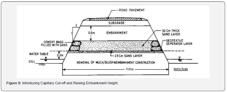
The most used techniques, to control groundwater are the introduction of capillary cut-offs and raising embankment height or use of sub-surface drains. The former procedure entails dewatering of the subsoil, by extracting water from between the saturated soil pores, and diverting of surface water to natural drains. Muck and slush are then removed from the surface to pave way for the embankment

As shown in (Figure 8), a capillary cut-off sand layer is then introduced, after the placement of a geo-textile separator layer. This serves as a preventive mechanism against the migration of fine soil particles from underlying soft soils, which have the propensity to clog the sand layer. The tremendous cost associated with this construction method which may be warranted in extremely poor soil conditions, such as that of the Chikoko clayey peaty soils widespread in the swamps, is self-evident. As alternative to the above procedure, lowering the water table can be achieved by use of adequate sub-surface drainage measures. This entails constructing deep buried drains also referred to as ‘Trench Drains, along the length of the road pavement in the water-logged sections to lower the natural water-table. This is however more feasible in situations where the soil properties are not so bad. However, the sides of trenches generally lose the ability to retain their original vertical position in the typical soft soils of the riverine areas, which may cause it to cave in. This behaviour of the soils is rectified by timbering with poling boards placed side by sides, walled and strutted along the sides of the trench. Alternatively, the trenches may also be sheeted. The ground excavations are done 225mm depth at a time, and on reaching each 225mm depth in excavation; the poling boards are placed in pairs, one on each side of the trench against the sheeting and strutted. The associated cost of excavation, sheeting and timbering are further additional cost, for drainage construction in the swampy and coastal areas.
Adequate drainage design and construction, in consideration of the intricate hydro-geotechnical dynamics of the Niger Delta region is thus a major consideration for highway pavement construction. The Transportation and Road Research Laboratory [28] Road Note 6, Guidance Notes on Road Pavement Drainage Design, emphasized the impact of surface drainage on the design of road pavements and the need for simultaneous design of both parts of a road. The design guide listed several geomorphologic factors, in addition to estimated volume of maximum rainfall expected in an area, which will determine the overall design of drainage: The surrounding terrain (slope and rate of runoff): subgrade soil (permeability and other drainage characteristics; ground water table (depth). In relating these drainage design and construction requirements to the archetypical features of swampy and coastal locations of the Niger Delta region, considerations must be given to the following:
a. The coastal terrain has a generally flat topography which does not encourage rapid run off of surface water. Particularly in the low lying back-swamps of the fresh water and saltwater zones, surface water can hardly be drained off by gravity. A very slight gradient (higher than in the swampy regions) however exists in the upland coastal plain regions, which allows faster run-off of surface water.
b. The soils are predominantly much finer grained in the swamps than in the upland plains, which is indicative of their very low permeability and drainage characteristics. These soils which are generally highly plastic tend to hold water in their pores. However, in the upland regions, the stratigraphy of the soils reveals higher content of permeable sands intercalated with silts and pockets of clays, resulting in their silty-sandy profile. This implies a higher rate of infiltration into the ground upon the occurrence of heavy downpours.
c. Water-logging of soils, from clayey sub-soils with high ground water tables in the swamps and coastal islands, often occur, as parts of the region generally exist in a state full or near saturation conditions, with little or no capacity for infiltration of the high volume of overland flow during the rainy season months. Waterlogging is however not common in the uplands, due to the predominantly less cohesive, more permeable soils and lower ground water profile, that encourages rapid infiltration of rainfall into the ground.
In view of the intricate hydrological balance between subsurface and surface water in the Niger Delta, the cost associated with the construction of highway drainage will depend on the hydro-geomorphological attributes of the project location.
Conclusion
The inherent peculiarities of the Niger Delta terrain serve as a strong geologic justification on the need to exploit every avenue for ensuring value for money. The geomorphological attributes of the Niger Delta have a significant impact in determining the design and construction cost of highway projects. Effective practical measures are needed to improve the engineering characteristics of the highly compressible silty clay soils and managing construction activities. Riverine and coastal zones require the construction of adequate and expensive pavement and road drainage systems of higher design standards to cater for subsoil conditions, surface water flow and ground water. These are summarily captured in Table 6. All these measures translate to additional cost for road projects in coastal and swampy areas, whose prohibitive cost has been sometimes termed as ‘unfeasible’ and to which the almost complete absence of highway development of these areas has being attributed. Recognising the geotechnical challenges and cost associated with the adverse geologic configuration of most parts of the Niger Delta, is thus considered a necessary starting point to maximise value for money in highway projects.

For more about Juniper Publishers please click on: https://juniperpublishers.com/journals.php
For more Civil Engineering articles, please click on: Civil Engineering Research Journal
https://juniperpublishers.com/cerj/CERJ.MS.ID.555785.php


Comments
Post a Comment