Numerical Modeling in Flood Risk Assessment: UK Case Study- Juniper Publishers
Juniper Publishers- Journal of Civil Engineering
Abbreviations
Abbreviations:
(CES): Conveyance Estimation System; (DCM): Divided Channel Method;
(HEC-RAS): Hydrological Engineering Centre River Analysis System; (SCM):
Single Channel Method
Introduction
River flooding is one of the greatest natural
threats to mankind, causing human fatalities, displacement of people and
economic losses. In addition to economic and social damage, floods may
have severe environmental consequences. In 2007, Britain faced a summer
of devastated storms, with thousands of homes and businesses under
water, and thirteen fatalities. Although the UK Government has hugely
invested in outstanding research and defenses to overcome this problem,
the 2015 winter floods on Cumbria seemed to indicate that nothing has
changed.
Some of the reasons for increasing flood scenarios
are out of the Civil Engineers' scope. Climate change as well as in
appropriate river management and land use in flood plains are raising
the flood risk and vulnerability [1].
These are external actions we have to take into account and civil
engineers do not have the key to change them. However we have the
knowledge to predict how rainfall is going to affect buildings and infra
structures (such as roads, railways, etc.) and what actions must be put
in place to reduce flood risk. The understanding of the behavior of
rivers during flood periods in order to accurately predict water levels
is essential for the design of flood alleviation works. There are
numerous methods and approaches that have been employed in recent times
to facilitate accurate estimation and prediction of discharge,
conveyance and water surface level of rivers during over bank flow.
The UK Environment Agency has developed several reports in order to reduce uncertainty in flood level estimation [2]
and to improve understating of numerical modeling in rivers (SC120002/R
Technical report on latest benchmarking results and SC080035/SR
Technical report on theoretical basis). However a gap in the knowledge
about how 1D/2D numerical models estimate water levels and velocities
during overbank flow is still remaining. The aim of this paper is to
summarize the application of quasi two dimensional Conveyance Estimation
System (CES), developed by the UK Environment Agency, and compare the
results to that of the traditional 1D methods, Single Channel Method
(SCM) and Divided Channel Method (DCM) using Hydrological Engineering
Centre River Analysis System (HEC- RAS) software. The two-dimensional
SRH-2D [3]
model is also used for comparison of water levels and velocity
distributions. A great effort has been made over the last decades to
improve calculation of water levels and velocities in real rivers by the
use of 2D and 3D modeling. However some important uncertainties are
still unsolved. In this context, an accurate 1D model easy to calibrate
and with the support of the CES is proposed as an improved tool for
comparison.
Methodology
One dimensional hydraulic model has been successfully
used during years for flood simulation in rivers. However, during the
last 20 years the extensive development in computational capacity has
increase the research and practical use of two dimensional modeling. In
this research the use of both 1D and 2D modeling is proposed. The 1D
HEC-RAS simulation model [3] and the CES model (Environment Agency, 2004), are compared with the 2D SRH-2D model by the U.S. Bureau of Reclamation [4]
in terms of water levels, velocity distributions and flood extension.
For unsteady flow, HEC-RAS solves the full, dynamic, 1D Saint Venant
Equation using an implicit, finite difference method. The SRH-2D solves
the 2D dynamic wave equations, i.e., the depth averaged St. Venant
equations with the finite volume numerical method. The Environment
Agency's CES model is based on the LDM [5,6]
and it combines the continuity and momentum depth averaged equations of
motion for steady conditions and in the stream wise component. The
general equation of the model for a straight river (sinuosity equal 1.0)
is obtained.
The simulation of the study reach of river Main (UK's
Northern Ireland) on both CES and HEC-RAS computational modeling
software and the two dimensional code SRH2D have been calibrated with
the field data [7,2].
The three codes have been applied by using the same boundary
conditions, cross section data and flow parameters in order to have the
same criteria for comparison and validation. Finally the water surface
level and velocity distribution results obtained from these codes were
analyzed and compared with the available field data to validate and
verify the results. Figure 1 shows a full graphical description of river Main geometry and study length.

Results and Conclusion

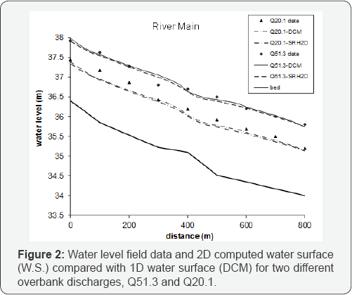
The water levels obtained with HEC-RAS and SRH2D for the two overbank discharges (20.1 and 51.3 m3/s) are shown in Figure 2
HEC-RAS use two different methods for the calculation of water levels.
The bank stations are located on the top of the main channel (DCM) or on
the top of the flood plain walls (SCM) and two separated solutions are
obtained. Only the DCM solution is shown here as the DCM gives lower
water levels than the SCM for the same discharge. The results obtained
with SRH2D model are shown in the same Figure. The water level profiles
obtained with 2D modeling ( turbulence model) are lower than those
obtained with the DCM for all the discharges. The Manning's coefficients
are the same in both models, as well as the boundary conditions.
However, 2D modeling has some advantages over 1D
modeling. First, the changes in main channel and floodplain sinuosity
are taken into account; second, it considers internal energy losses due
to flow turbulence; and third, consequently the velocity direction and
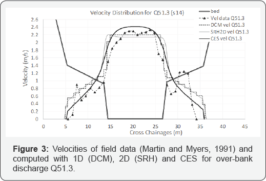
distribution is better simulated. In Figure 3 the velocity distribution obtained with 1D [8]
(DCM) and 2D models are compared with field measurements. The
velocities given by SRH2D improve slightly the velocities obtained with
DCM. In order to improve 1D modeling, the results obtained with CES are
discussed [9].
The first step is that for straight river channels with moderate
roughened flood plains, the water profiles obtained with1D model are
better than with the 2D model. However, the distribution of depth
averaged velocity can be obviously improved. The CES is applied to
section 14 (Figure 3), using the same bed slope and Manning's coefficient of roughness than in 1D modeling. Figure 3 shows that the velocity distribution obtained with CES fits better with the data than the distribution given by 2D model.

This study illustrates some of the problems that
affect common 1D numerical models in reproducing overbank flow. 1D
models are not able to yield an accurate velocity distribution across
the section of a straight compound channel. Secondly, the comparison
between the field data and the SRH2D model shows the need to take into
account that the Manning’s coefficients valid for 1D modeling are not
accurate enough for 2D simulations. Therefore, some uncertainties rising
from the use of 2D models can provide uncertain results respect to
better predictable estimations obtained by 1D modeling. The prediction
of accurate water levels and velocity distributions in overbank flows is
a major challenge in numerical modeling. Typical 2D finite volume codes
based on turbulence model trend to under predict main channel and flood
plain interaction. These 2D models slightly improve the depth-averaged
velocities obtained with 1D model for the straight river case analyzed
here in. In order to better simulate velocities, the CES based on
Lateral Distribution Method is proposed for comparison. The CES gives a
better representation of momentum interaction between main channel and
flood plains and of the velocity distribution across the section. This
methodology has been contrasted with field river data under gradually
varied conditions, confirming the results of some previously published
works on the topic under different conditions [10].
For More Open Access Journals Please Click on: Juniper Publishers
Fore More Articles Please Visit: Civil Engineering Research Journal


Comments
Post a Comment