Satellite-Based Big Data for Resilience of Critical Infrastructures Subjected to Natural and Man-Made Disasters- Juniper Publishers
Juniper Publishers- Journal of Civil Engineering
Editorial
During natural and man-made disasters,
infrastructures are subjected to cyclic combined flexural, axial and
shear forces. The safety and serviceability of infrastructures are
critical because their failure can have catastrophic consequences. The
capacity of infrastructure to recover quickly from disasters is urgently
needed and this requires sound decision making. Hence, The Engineering
for Natural Hazards (ENH) program at the National Science Foundation
encourages research that advances knowledge for understanding and
mitigating the impact of natural hazards (earthquakes, tornadoes,
hurricanes, tsunamis, storm surge and landslides, etc) on constructed
civil infrastructures. Considering civil infrastructure performance over
its lifetime, the potential of multiple hazards to the infrastructures
is high.
The potential impact of natural and man-made
disasters such as earthquakes, tornados, tsunamis, blasting and missile
attacks increases significantly for critical infrastructures. Therefore
it is extremely important that the resilience of such infrastructures be
maintained in order to keep the economic loss to a minimum. Space-borne
satellites acquiring information on the earth’s surface routinely will
provide rich data. Big data is huge and complex data sets, including
catch, curation, hunt, sharing, analysis, storage, convey, visualization
and private information. Space-borne satellites to acquire information
(such as deformation of the infrastructure, water level of flooding,
etc) on the earth’s surface are needed to critically examine the damage
level of the infrastructure.
Combining the finite element analysis results for the
targeted critical infrastructures will produce large and complex data
sets that can be stored in big data. The critical infrastructures can be
visualized as assemblies of various elements. The behavior of a whole
structure can be predicted if the behavior of each element is thoroughly
understood. Using OpenSees as a framework, a finite element analysis
(FEA) program to predict the nonlinear behavior of infrastructures
subjected to multi-hazards is developed at the University of Houston. In
the formulation, we develop the constitutive relation and various
element modules with a model-based simulation approach by taking into
account the Cyclic Softened Membrane Model also developed at the
University of Houston. To form a FEA program, the constitutive relation
modules and the analysis procedure were implemented into a finite
element program development framework, OpenSees, developed at UC
Berkeley. By analyzing the data collected by satellite after impact and
the analytical outcomes of the targeted infrastructures, a resilience
methodology can be quickly developed that will be very helpful for the
decision makers.
Satellite-based big data can be employed to guide the
finite element analysis of critical infrastructures and to evaluate the
damage level for resilience purposes. The developed finite element
program (Simulation of Concrete Structures, SCS) is able to accurately
predict the nonlinear, dynamic behavior of critical infrastructures
subjected to natural hazards or man- made disasters using satellite
collected data to trace the loading history and to obtain the damage
level for resilience purposes. Through finite element analysis and the
data collected by satellites in the big data, a robust and effective
“resilience methodology” can be developed for the decision makers.
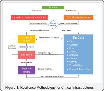
(Figure 1)
shows the flow chart of the resilience methodology for critical
infrastructures. When disaster occurs, real-time data of the
pre-selected critical infrastructures and the surrounding environmental
conditions are captured and integrated by the satellite, which will be
immediately uploaded to the big data system for further processing.
Meanwhile, this satellite-based integrated information, such as
environmental conditions, structural deformation status and any other
accessible data, will be applied as the inputs for the analysis
procedure. Once the satellite-based information is updated, the big data
system can provide a rough estimation of the critical infrastructures’
damage level and current status based on the previous corresponding data
and similar cases in a very short response time.

On the other hand, with the satellite-based
information collected, the FEA program can simulate the real damage
status of the infrastructures, which provides much more accurate and
reliable results for the following structural assessment purpose.
Although the two results are derived using different methods, the
satellite-based data can be used to verify the analytical outcomes. Once
the analytical results are verified, it will be passed to the
resilience program as an important reference data, together with the
historical damage records from the big data system, which in turn
proposes the most robust and effective resilience methodologies for
keeping the economic loss to a minimum.
The proposed resilience plan, which is a
highly-integrated methodology containing the contribution and progress
from both the FEA program and the Big Data System, will be delivered to
the resilience committee for the final decision making, The incredible
advantage of these two systems enables the committee to have the most
feasible and the most time- and cost-effective method for the disaster
recovery. And of course this method will also be uploaded to the big
data system for future reference purposes. With more and more cases
analyzed and input to the big data system, this continuous developing
database tool will be stronger and smarter day by day, case by case. Its
self-study character not only helps people to make quick response to
any disasters, but also ensures that the best choice can always be made.
The intellectual merit of the proposed work on
Satellite- based Big Data for Resilience of Critical Infrastructures is
that this research will demonstrate whether sound decisions can be made
to provide resilience of infrastructures and hence greatly reduce the
economic loss. The impact of the proposed work would be significant,
because although the failure of infrastructures can have catastrophic
consequences, the simulation tools for the entire process of the
proposed concept do not exist. The use of a widely available open-source
framework will ensure that this capability can be used by a broad
community of engineers and researchers.
For more open access journals please visit: Juniper publishers
For more articles please click on: Civil Engineering Research Journal


Comments
Post a Comment